
Welcome!
Welcome to the web pages of the USDA Forest Service National Lichens and Air Quality Database and Clearinghouse. Across the US, lichen biomonitoring is helping federal land managers meet federal and agency responsibilities to detect, map, evaluate trends, and assess the ecological impacts of air pollutants. On these pages you can access lichen data from the National Forest system and the Forest Inventory and Analysis Programs and find out more about lichens and lichen monitoring in general.
Overview
The FS has been collecting lichen data since the 1970s, with nationwide emphasis beginning in 1993. Since 1993, the National Forest System (NFS) and the Forest Inventory and Analysis Program (FIA) have collected lichen data on forestland. This database unites data collected by the USFS as well as partnering agencies and researchers, including data on both community composition and elemental analysis of lichen tissue. As of November 13, 2017, the database houses 171,489 lichen records and 15,383 lichen tissue samples collected on 10,623 plots and is usually updated annually to include new data and add new functionality. Most data focus on macrolichen (non-crustose) epiphytes in forest habitats although some data on ground, rock, and crustose lichens are available.
Data Contributors
NFS: The USFS Air Program conducts lichen surveys and collects lichens for elemental analysis on sites within the national forest system. Because Wilderness air quality is more stringently protected under the Clean Air Act, much of the focus is on Wilderness. Actual plot coordinates and elevations are provided for surveys on non-FIA plots. On FIA-plots, fuzzed coordinates are provided (see FIA below). Overall, the Air Program uses lichens to tell us how air pollution and climate are affecting the forested landscape and how we are doing as managers in mitigating changing atmospheric conditions and pollution. Most of the lichen data is accompanied by measured and modeled site data related to forest structure and composition, physical and ecological characteristics, climate, and air quality. For questions please contact Linda Geiser.
FIA: The FIA Program collects forest measurements on a systematic grid across the United States. Most FIA lichen surveys can be linked to data on trees, invasive plant species, understory vegetation, down woody material and soils (http://apps.fs.fed.us/fiadb-downloads/datamart.html). Plots include both public and private land so geographic coordinates for FIA plots are "fuzzed" to protect landowner privacy. Most coordinates fall within 0.5 mi of the actual plot location. For questions please contact Sarah Jovan.
Website Features
- Database Queries
Query the USFS database of lichen species by geographic area or sensitivity class; retrieve lichen elemental analysis data - Elemental Analysis Thresholds & Sensitivity Ratings
Aids for interpreting lichen data - Reports, Publications & Protocols
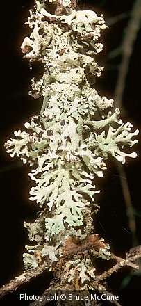
Full articles, citations and PowerPoint presentations pertaining to lichens and air quality monitoring in national forests and parks - Lichen Images
Get a drawing or photograph of a lichen, submit your own images - Fun with Lichens
Resources for teachers, students, naturalists - Links to Other Resources
Websites for further exploration - Lichens and Air Quality Workgroup Homepage
Uses of lichen data by federal land managers, resources for managers, ongoing federal and university programs - Air program Contacts
Regional contacts for USFS Air Resource Managment